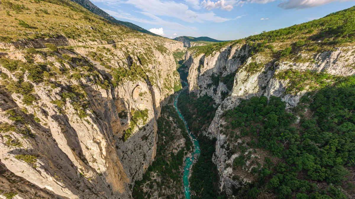
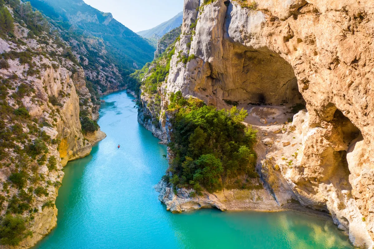
The Grand Canyon du Verdon from above — white limestone cliffs hundreds of metres high, with the turquoise Verdon far below
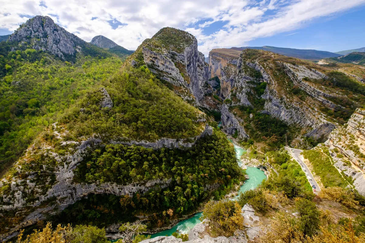
View from the Point Sublime into the entrance of the canyon, with the turquoise river bending below wooded slopes and limestone peaks
France Gorges du Verdon Verified campsite to campsite, checked November 2026

Gorges du Verdon in 5 days

Europe's grandest canyon on foot: the GR 4 from Castellane over the rim to La Palud, a day in the gorge on the Sentier Blanc-Martel, then over the Col de Plein Voir to Moustiers and Lake Sainte-Croix.

Download GPX
Total distance
71.9 km
Walking days
5
Avg per day
14.4 km
Ascent / descent
+2,590 / −2,950 m
Difficulty
Challenging
Best period
May – Sep
Route type
Point to point
Solid line: planned track along OpenStreetMap paths. Dashed: no track yet. Map: OpenFreeMap / OpenStreetMap.

Elevation profile

400 800 1200 0 km10 km20 km30 km40 km50 km60 km70 km Day 1 Day 2 Day 3 Day 4 Day 5
From 475 m to 1376 m over 71.9 km. Elevation in metres, from the planned track.

Photos from the trail

1 / 3
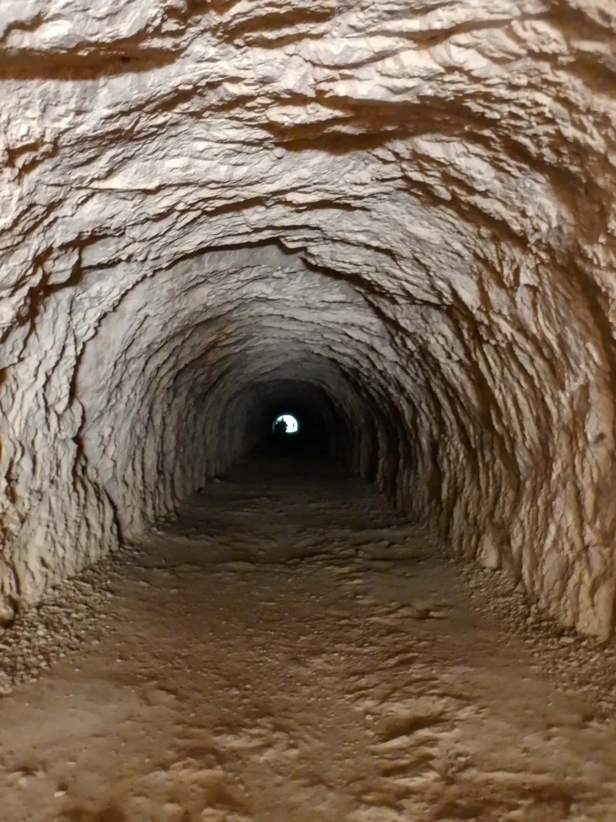
A long tunnel hewn through the limestone on the Sentier Blanc-Martel, with daylight at the far end
One of the tunnels on the Sentier Blanc-Martel — bring a torch (day 3)
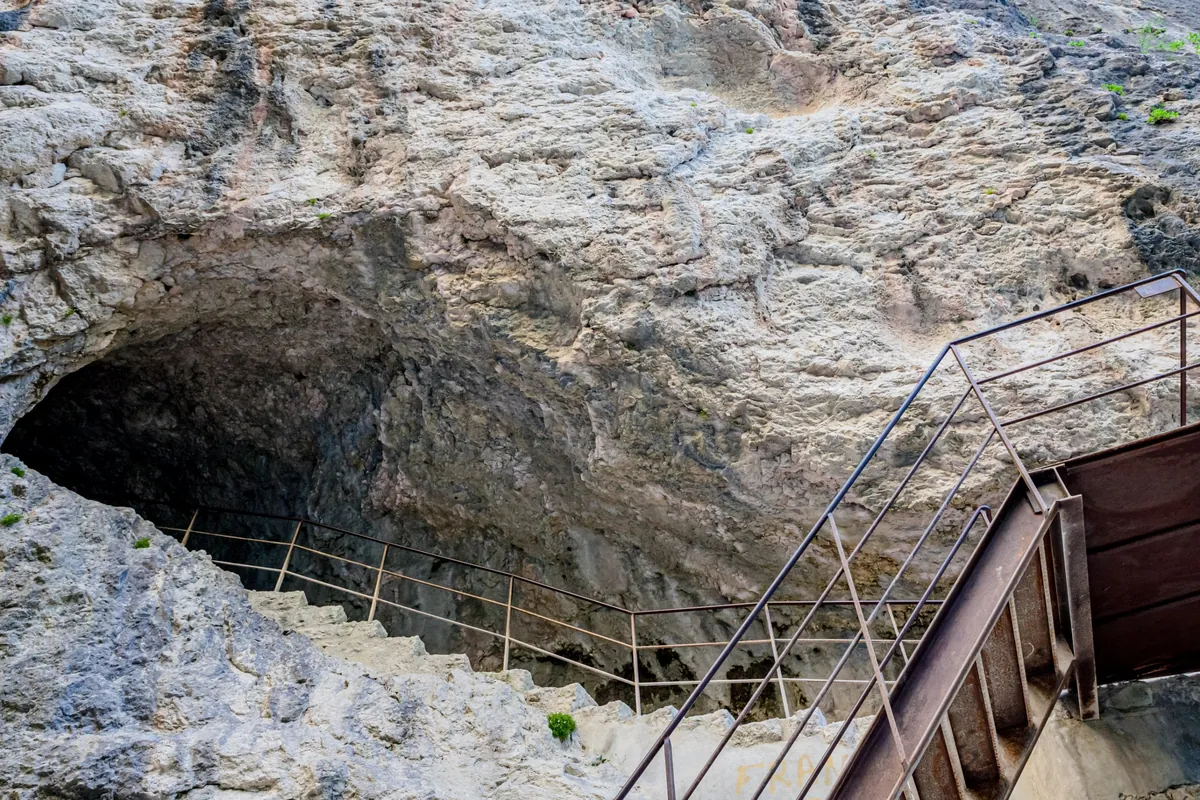
Steel stairs and a railed path climbing past a huge cave mouth in the limestone wall of the gorge
Stairs past a cave on the Sentier Blanc-Martel (day 3)
The turquoise Verdon leaving the canyon between pale cliffs towards Lake Sainte-Croix, with a single kayak on the water
Where the gorge meets Lake Sainte-Croix (day 4 – 5)

When to go

The top row shows when the trail itself is in good condition (snow, heat, services). Below it, when each campsite is open — the trek works when both line up. Trail conditions can differ from year to year, so always keep an eye on local websites before and during your trek.

When the trail is in condition, opening months per campsite, and when all campsites are open together
Row AprMayJunJulAugSepOct
Trail season Not advisedBestBestPossiblePossibleBestNot advised
Campsites open
Chasteuil (Castellane) ClosedOpenOpenOpenOpenPartClosed
La Palud-sur-Verdon OpenOpenOpenOpenOpenOpenPart
Moustiers-Sainte-Marie OpenOpenOpenOpenOpenOpenPart
Les Salles-sur-Verdon OpenOpenOpenOpenOpenOpenOpen
All campsites open ClosedOpenOpenOpenOpenPartClosed

Day by day

Day 1: Castellane → Chasteuil (Castellane)

Distance
11.8 km
Up / down
+270 / −320 m
Walking time
3h 45

Landscape

Out of Castellane below its chapel rock and along the slopes above the Verdon on the GR 4, past Chasteuil, then down to the river.

Along the way

Notre-Dame du Roc above Castellane; the old hamlet of Chasteuil under the Cadières de Brandis cliffs.

Water & groceries

Everything in Castellane — buy food for two days. Nothing on the way.

Tonight

Camping Domaine Chasteuil Provence. Riverside campsite below Chasteuil, about 800 m off the GR 4 (included in today's distance).

Day 2: Chasteuil (Castellane) → La Palud-sur-Verdon

Distance
14.2 km
Up / down
+770 / −550 m
Walking time
5h 30

Landscape

Back up to Chasteuil and over the open Suech plateau high above the gorge, then along the rim to La Palud-sur-Verdon.

Along the way

Wide views over the Suech plateau and the Couloir Samson; the perched village of Rougon above the Point Sublime.

Water & groceries

Little on the way — a café in Rougon in season. Shops and restaurants in La Palud.

Tonight

Camping Municipal Le Grand Canyon. Simple municipal campsite on the edge of La Palud — no booking needed. You sleep here two nights.

Day 3: La Palud-sur-Verdon → La Palud-sur-Verdon

Distance
12.5 km
Up / down
+520 / −630 m
Walking time
4h 30

Transfer to the start (bus, 20 min): walk 10 min from the campsite to La Palud-sur-Verdon (village), ride to Chalet de la Maline. Morning departures; daily 1 July – 15 September, otherwise Friday – Sunday. Book online.. The Blanc-Martel shuttle. In the afternoon it brings you back from the Point Sublime to La Palud.

Landscape

Down from the Chalet de la Maline to the bottom of the canyon and along the Verdon, with ladders, stairs and two tunnels, up to the Point Sublime.

Along the way

The Sentier Blanc-Martel — the classic walk through the Grand Canyon du Verdon; the Brèche Imbert ladders; the Couloir Samson.

Water & groceries

No water in the gorge — carry at least 2 litres. Café at the Point Sublime.

Tonight

Camping Municipal Le Grand Canyon. Take the afternoon shuttle from the Point Sublime back to La Palud. Bring a torch for the tunnels. Leave your tent pitched and walk with a day pack.

Day 4: La Palud-sur-Verdon → Moustiers-Sainte-Marie

Distance
17.4 km
Up / down
+690 / −1,030 m
Walking time
6h 30

Landscape

Up out of La Palud onto the ridge, over the Col de Plein Voir and the Col de l'Âne, then a long descent to Moustiers.

Along the way

The Col de Plein Voir, with views over the end of the canyon and the turquoise Lake Sainte-Croix; Moustiers-Sainte-Marie with its star above the gorge.

Water & groceries

No shops on the way — fill up in La Palud. Everything in Moustiers.

Tonight

Camping Saint-Jean. Campsite below the village, about 300 m off the GR 4. The longest day, but there is no campsite in between.

Day 5: Moustiers-Sainte-Marie → Les Salles-sur-Verdon

Distance
16 km
Up / down
+340 / −420 m
Walking time
5h

Landscape

Down from Moustiers to Lake Sainte-Croix and along its wooded northern shore to Les Salles-sur-Verdon.

Along the way

Moustiers' faience workshops; the turquoise lake and its beaches — finish with a swim.

Water & groceries

Shops in Moustiers. Beach cafés along the lake in summer; shops in Les Salles.

Tonight

Camping Municipal Les Ruisses. Large municipal campsite 200 m from the lake. Arrive during reception hours (afternoon).

Walking times are calculated with the DIN 33466 hiking formula (4 km/h, 300 m/h up, 500 m/h down), without breaks.

About this trek

The Gorges du Verdon is Europe’s grandest canyon: 21 kilometres of limestone cliffs up to 700 metres high, with the turquoise Verdon far below. Most visitors see it from the car. This route walks it.

From Castellane the GR 4 climbs along the slopes to Chasteuil and crosses the high Suech plateau to La Palud-sur-Verdon. There you stay two nights: on day 3 a small shuttle takes you to the Chalet de la Maline, and you walk the famous Sentier Blanc-Martel along the bottom of the canyon to the Point Sublime — with only a day pack. Then the GR 4 takes you over the Col de Plein Voir to Moustiers-Sainte-Marie, and the last day ends with a swim in Lake Sainte-Croix.

The shuttle day. The Blanc-Martel shuttle runs daily in July and August and until 15 September, and only Friday to Sunday in spring and autumn. Plan day 3 on a shuttle day and book ahead.

Why campsite to campsite here? Every village along the canyon has a campsite, and they are simple and good value. Hotels in the Verdon are expensive and full in summer.

Campsite to Campsite check

Automatic check of our eight conditions.

  • Every night at a regular campsite that accepts tents
  • Every campsite reachable on foot from the route
  • Each stage starts where yesterday ended — at most a short transfer of 30 minutes, always shown
  • No wild camping or bivouacs needed
  • No huts, hotels or hostels as standard overnight
  • All campsites open during the stated season
  • Daily distance and ascent measured and checked
  • Walkable with a full trekking pack

GPX downloads

Works with Garmin, Komoot, OsmAnd and other apps.

Walked it recently?

Report a closed campsite, a detour or a new water point. Every report is checked before the route changes.

Report an update

Gorges du Verdon in 5 days